
Principal Investigator: Keryn Gedan, George Washington University
Co-Principal Investigator: Man Qi, George Washington University
Years Funded: 2019-2021
Project Description:
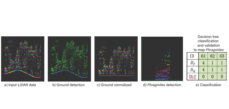
Wetlands across North America are being invaded by the introduced lineage of the common reed Phragmites australis. In the Mid-Atlantic, P. australis has been rapidly expanding, especially at tidal marsh-forest ecotones where sea level rise-driven forest deterioration provides an invasion window for this species. Early detection of P. australis at the marsh-forestt ecotone will be critical to the management of this invasive species in coming decades. In this project, we propose an early detection method for P. australis designed especially for areas of sparse to moderate tree cover. The method will use airborne LiDAR data which can penetrate the tree canopy and reach subcanopy vegetation layers, allowing for species mapping impossible with remotely sensed spectral data, the current focus of vegetation mapping efforts. To test and validate this methodology, we will take advantage of airborne LiDAR data for the Delmarva Peninsula collected in 2018 and 2019 by NOAA. We will conduct field surveys of P. australis and other understory communities of similar height to train and validate classification algorithms. Consequently, a spatial distribution map of P. australis within the marsh-forest ecotone for Blackwater National Wildlife Refuge and Deal Island will be provided to conservation agencies and land managers. Prior efforts to map P. australis were completed with visual surveys that did not include areas under forested canopy. Our proposed method will provide a more comprehensive map that could be updated whenever new LiDAR data is flown, and for less effort.
Image credit: Keryn Gedan, George Washington University